Софт → PixGPS v1.1.4
Скачать бесплатно PixGPS v1.1.4

Программа позволяет сохранять в мета-данных EXIF цифровых снимков информацию о широте и долготе места, где была сделана та или иная фотография. Для работы с PixGPS нужен цифровой фотоаппарат и GPS-приемник с возможностью отслеживания местоположения. PixGPS сравнивает информацию, имеющуюся в цифровых снимках, с логом GPS-приемника и вычисляет широту и долготу для каждой фотографии. Позиция места съемки может быть сохранена в мета-данных снимка или показана на карте.
PixGPS is a simple program for Microsoft Windows that makes it simple to insert the exact position of each photo (latitude and longitude) into the photos EXIF meta data. PixGPS - Geotag your digital photos. Have you ever wanted to know the exact position of where your digital photos were taken? All you need is: a digital camera that stores EXIF inside the image file (most cameras do this) a GPS Receiver that can store track logs in GPX format.the PixGPS software.
It's simple!
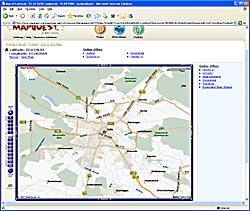
PixGPS makes it easy to geotag your digital photos. Just download the photos from your camera and get the GPX formatted track log from your GPS Receiver. The PixGPS Geotagger will in matter of seconds calculate the latitude and longitude for each of the photos. It will store the latitude and longitude in each photos EXIF meta data so it will stay with the photo. You can later use other software with EXIF GPS support to view the exact location of the photo, or you can use whe simple 'View on map' function in PixGPS to view the location in Google Maps or MapQuest (requires an Internet connection).
Who needs Geotagging?
For many of us, geotagging the digital photos are really useful. Of course it depends on what kind of photos you take, but if you take photos when travelling, it can be useful to see where you took photos on this trip. Let's say you take photos in a city. Will you remember were you took the photo of that building? PixGPS Geotagger can tag the photos location within 10 meters/30 ft. *)
For businesses that uses photography to document their work, storing the exact latitude and longitude in the photos EXIF meta data can be essential for future documentation.
3 ноября 2009 Добавил: Hengmen Просмотров: 618 Комментарии: 0

Программа позволяет сохранять в мета-данных EXIF цифровых снимков информацию о широте и долготе места, где была сделана та или иная фотография. Для работы с PixGPS нужен цифровой фотоаппарат и GPS-приемник с возможностью отслеживания местоположения. PixGPS сравнивает информацию, имеющуюся в цифровых снимках, с логом GPS-приемника и вычисляет широту и долготу для каждой фотографии. Позиция места съемки может быть сохранена в мета-данных снимка или показана на карте.
PixGPS is a simple program for Microsoft Windows that makes it simple to insert the exact position of each photo (latitude and longitude) into the photos EXIF meta data. PixGPS - Geotag your digital photos. Have you ever wanted to know the exact position of where your digital photos were taken? All you need is: a digital camera that stores EXIF inside the image file (most cameras do this) a GPS Receiver that can store track logs in GPX format.the PixGPS software.
It's simple!
PixGPS makes it easy to geotag your digital photos. Just download the photos from your camera and get the GPX formatted track log from your GPS Receiver. The PixGPS Geotagger will in matter of seconds calculate the latitude and longitude for each of the photos. It will store the latitude and longitude in each photos EXIF meta data so it will stay with the photo. You can later use other software with EXIF GPS support to view the exact location of the photo, or you can use whe simple 'View on map' function in PixGPS to view the location in Google Maps or MapQuest (requires an Internet connection).
Who needs Geotagging?
For many of us, geotagging the digital photos are really useful. Of course it depends on what kind of photos you take, but if you take photos when travelling, it can be useful to see where you took photos on this trip. Let's say you take photos in a city. Will you remember were you took the photo of that building? PixGPS Geotagger can tag the photos location within 10 meters/30 ft. *)
For businesses that uses photography to document their work, storing the exact latitude and longitude in the photos EXIF meta data can be essential for future documentation.
Уважаемый посетитель вы вошли на сайт как незарегистрированный пользователь. Мы рекомендуем вам зарегистрироваться либо войти на сайт под своим именем.
Похожие новости
Информация
 |
Посетители, находящиеся в группе Гости, не могут оставлять комментарии к данной публикации. |
Календарь ↓
| « Февраль 2026 » | ||||||
|---|---|---|---|---|---|---|
| Пн | Вт | Ср | Чт | Пт | Сб | Вс |
| 1 | ||||||
| 2 | 3 | 4 | 5 | 6 | 7 | 8 |
| 9 | 10 | 11 | 12 | 13 | 14 | 15 |
| 16 | 17 | 18 | 19 | 20 | 21 | 22 |
| 23 | 24 | 25 | 26 | 27 | 28 | |
Архив сайта ↓
Декабрь 2024 (5)
Ноябрь 2024 (31)
Сентябрь 2023 (1)
Сентябрь 2021 (9)
Май 2021 (3)
Апрель 2021 (1)
Друзья ↓
» Порно видео онлайн
» Ведьмак смотреть онлайн
» Сокол и Зимний Солдат смотреть
» Фильмы и сериалы онлайн
»
»
» Скачать Warcraft 3
»
Обмен ссылками закрыт!


